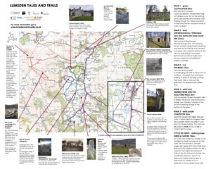
Visit the Lumsden Trails and Tales for information, maps, walking, cycling and driving routes, photos, audio stories, fictional adaptations and Lumsden music.
Lumsden is set between the foothills of the beautiful Cairngorm mountains and the north east Moray coast. Alford is the nearest village, (approximately 8 miles south), with most of the amenities you expect of a larger village such as a supermarket, butcher, bakery, cafes, restaurants and pubs, swimming pool, sports centre, library etc. (follow links on the left hand side for more details). In the opposite direction is Huntly, a larger town, which is 15 miles north.
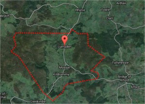
Lumsden’s immediate surrounds include Clova, Mossat and Kildrummy to the west and The Craig to the north. Slightly further afield are Glenkindie and Towie to the west and Rhynie to the north.
The area is an ideal base for many outdoor pursuits being within 30mins of the Lecht Ski Centre 20mins to Clashindarroch Forest and it’s cross country skiing tracks. The quiet country roads offer unrivalled road cycling routes with challenging mountain climbs and is home to the ‘Etape Royale’ annual closed road event. Mountain biking is also popular, with many miles of estate tracks and routes suitable for families and more experience riders alike.
Although Lumsden Community extends to include anyone throughout the world with links to this area, the physical catchment area that most people accept as within the Lumsden Community is illustrated below: